With the start of a new year and a new decade, I couldn’t help but think back on my time here in Crested Butte. While a lot has changed, many things have stayed the same. While I don’t have a time machine to go back in time and point out changes, I do have Google Earth and the tools that it has. So, I went back and made side by side images for some of the areas in Crested Butte that have seen the most changes over the past 20 years or so. The most recent Google Earth imagery is from 2015- which means that newer projects like the Arts Center or the Aperture neighborhood north of town won’t show up, nor will any other building from the past 5 years, of which there are many. The oldest imagery is from 1999, way back in the 20th century!
Town of Crested Butte
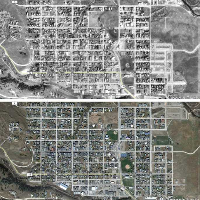
This is the town of Crested Butte from 1999 to 2015. Most noticeable is the Verzuh annexation on the Southeast side of town. In 1999, the streets were just being built. By 2015, this area was nearly full of homes. A keen eye will also notice that many of the vacant lots spread out through town also had homes by 2015. The Northeast part of town has seen a lot of construction over the past couple of years as well, although it isn’t as noticeable in the 2015 imagery.
Crested Butte South
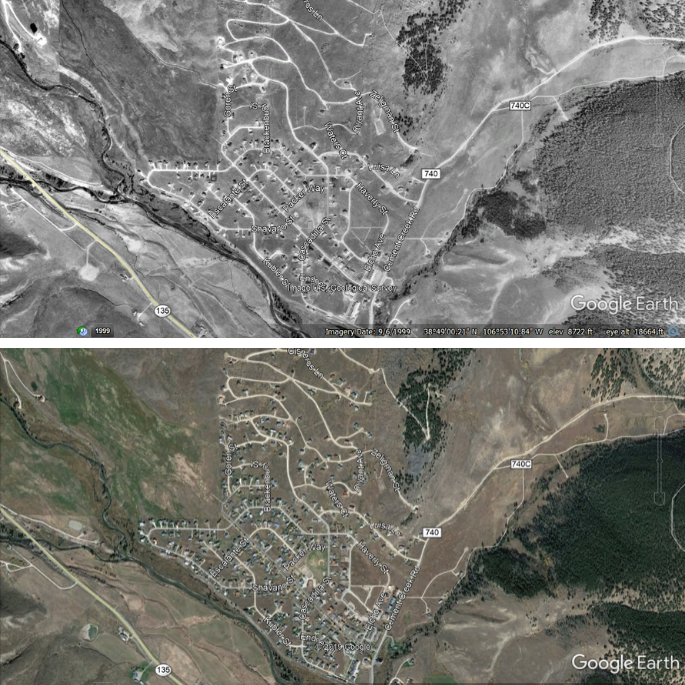
The photo above shows much of the growth that occurred in Crested Butte South over the past 20 years or so. It wasn’t that long ago that cows still roamed the subdivision in the fall. In the 90’s, vacant land in the upper reaches of CB South was generally sold three lots at a time- this was the only way to have a big enough lot (1 acre) to do a septic system before the sewer system reached up the hillside. Another big change in Crested Butte South was the growth of the commercial district- which now has a number of successful businesses in this thriving community.
Larkspur and Buckhorn Ranch
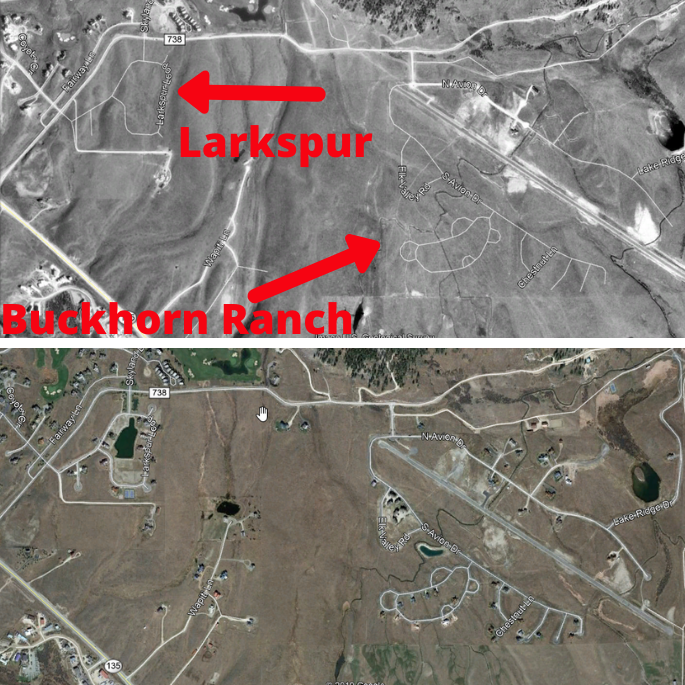
In these images, the differences are clear. Larkspur and Buckhorn Ranch didn’t even exist in 1999, other than the airplane landing strip at Buckhorn Ranch. Both of these areas have seen a flurry of building activity since then, especially in the past 5 years (which doesn’t show up due to the 2015 Google Earth imagery). The small subdivision of Butte Pasture on Wapiti Lane can also be seen.
Crested Butte Mountain Resort Base Area
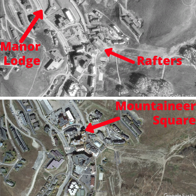
The CBMR base area saw a number of significant changes in this time frame. The Manor Lodge (also the site of Casey’s bar) was demolished and is now the parking structure near the Grand Lodge. Also demolished was the base area cafeteria known as Rafters, which is now mini-golf. The Swiss Chalet was demolished and is now the Black Diamond Lodge across the street from the Grand Lodge (not labeled). And the entire base area was transformed when the Lodge at Mountaineer Square and transportation center was built in 2006.
West Wall and Pitchfork
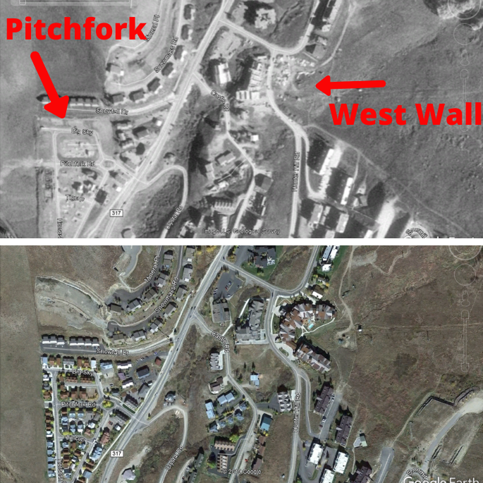
In 1999, the Pitchfork neighborhood was in the early stages of development, with just a few homes. Black Bear Lodge (not labeled) was under construction. Across the street, West Wall Lodge was only on the drawing board.
So there you have it- a look back in time to Crested Butte of the late 90’s. Do you have questions about other development in Crested Butte? Just ask!

